


ballade sur le GR 65

lahoche
User

Length
15.5 km

Max alt
225 m

Uphill gradient
310 m
Km-Effort
19.7 km

Min alt
106 m

Downhill gradient
311 m
Boucle
Yes
Creation date :
2021-03-15 15:34:44.085
Updated on :
2021-03-15 15:37:03.6
4h28
Difficulty : Easy

FREE GPS app for hiking
 SityTrail
IGN / Geographical institutes
SityTrail Plus
The world is yours!
About
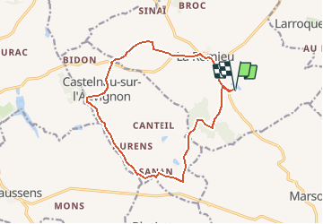
Trail On foot of 15.5 km to be discovered at Occitania, Gers, La Romieu. This trail is proposed by lahoche.
Positioning
Country:
France
Region :
Occitania
Department/Province :
Gers
Municipality :
La Romieu
Location:
Unknown
Start:(Dec)
Start:(UTM)
300199 ; 4871800 (31T) N.
Comments